Saturday, April 30, 2011

Shortest Mountain Range:Sutter Buttes

The Sutter Buttes are a small circular complex of eroded volcanic lava domes which rise as buttes above the flat plains of the Central Valley of California in the United States. The highest peak, South Butte, reaches about 2,130 feet (650 m) above sea level. The Buttes are located just outside of Yuba City, California in the Sacramento Valley, the northern part of the Central Valley. They are named for John Sutter, who received a large land grant from the Mexican government. The Sutter Buttes also hold the title of being the world's smallest mountain range.

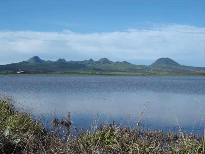
The mountains are about 10 miles (16 km) from north to south and east to west, and are the smallest mountain range in the world.
The Sutter Buttes were formed over 1.5 million years ago by a now-extinct volcano. Some geological references suggested that it represents the southernmost of the Cascade Volcanoes,[2] but there are significant differences in age and form compared to the other volcanoes in that range. The questions about their origin and connection to other regional volcanic activity are the subject of ongoing research.
The Sutter Buttes contain many flora and fauna speciesWildflowers are represented by numerous taxa; included in these many wildflowers is the Yellow Mariposa Lily,Calochortus luteus.

Friday, April 29, 2011

Longest Mountain Ranges:Andes Range

The Andes is the world's longest continental mountain range. It is a continual range of highlands along the western coast of South America. This range is about 7,000 km (4,300 mi) long, about 200 km (120 mi) to 700 km (430 mi) wide (widest between 18 degrees South and 20 degrees South latitude), and of an average height of about 4,000 m (13,000 ft).

Along its length, the Andes is split into several ranges, which are separated by intermediatedepressions. The Andes is the location of several high plateaux – some of which host majorcities such as QuitoBogotáArequipaMedellínSucre, and La Paz.
The so-called Altiplano plateau is the world's second-highest plateau following the Tibetan plateau. The Andes extends to seven countries, in alphabetical order: ArgentinaBolivia,ChileColombiaEcuadorPeru, and Venezuela, some of which are known as the Andean States.

Smallest Desert In The World:Carcross Desert

Carcross Desert, located outside Carcross, YukonCanada (60°11′14″N 134°41′41″WCoordinates60°11′14″N 134°41′41″W), is often considered the smallest desert in the world. Although, this is untrue with the Desert of Maine having an area of 40 acres (160,000 m2). The Carcoss Desert measures approximately 1 square mile (2.6 km2).

Carcross Desert is commonly referred to as a desert, but is actually a series of northern sand dunes; the areas' climate is too humid to be considered a true desert. The sand was formed during the last ice age, when large glacial lakes formed and deposited silt. When the lakes dried, the dunes were left behind. Today, sand comes mainly from nearbyBennett Lake, carried by wind. The dunes contain a wide variety of plants, including unusual varieties such as Baikal sedge and Yukonlupine, among others.
The Yukon Territorial government made efforts to protect Carcross Desert in 1992, but failed due to opposition from locals who use the dunes for recreational purposes.

Thursday, April 28, 2011

Largest Desert In The World:Sahara

The Sahara (Arabicالصحراء الكبرى‎ Aṣ Ṣaḥrā´ al KubrāEnglishThe Great Desert) is the world's largest hot desert. At over 9,400,000 square kilometres (3,630,000 sq mi), it covers most ofNorthern Africa, making it almost as large as Europe or the United States. The only larger desert in the world is Antarctica, classified as such because of very low precipitation rates. The Sahara stretches from the Red Sea, including parts of the Mediterranean coasts, to the outskirts of the Atlantic Ocean. To the south, it is delimited by the Sahel, a belt of semi-arid tropical savanna that comprises the northern region of central and western Sub-Saharan Africa.
Some of the sand dunes can reach 180 metres (590 ft) in height.[1] The name comes from the Arabic word for desert.
 .
Source:http://en.wikipedia.org/wiki/Sahara

Tuesday, April 26, 2011

Biggest Mall In The World:DUBAI MALL


The Dubai Mall is the world's largest shopping mall based on total area and sixth largest bygross leasable area. Located in DubaiUnited Arab Emirates, it is part of the 20-billion-dollarBurj Khalifa complex, and includes 1,200 shops.[1][2] Access to the mall is provided via Doha Street, rebuilt as a double-decker road in April 2009.[3]
Twice delayed, Dubai Mall opened on November 4, 2008, with about 600 retailers, marking the world's largest-ever mall opening in retail history. However it is not the largest in gross leasable space, and is surpassed in that category by several malls including the South China Mall, which is the world's largest, Golden Resources MallSM City North Edsa, and SM Mall of Asia.
The Dubai Mall has recorded a visitor turn-out of more than 60,000 tickets sold for the Dubai Aquarium and Discovery Centre in the first five days, following its opening.[4] The Dubai Mall hosted over 37 million visitors in its first year of operation,[5][6] and attracts more than 750,000 visitors every week.

Monday, April 25, 2011

Biggest Water Fall: Victoria Falls

The Victoria Falls or Mosi-o-Tunya (the Smoke that Thunders) is a waterfall located in southern Africa on the Zambezi River between the countries of Zambia and Zimbabwe. The falls are the largest in the world.
Victoria Falls is one of the most famous falls, considered to be among the Seven Natural Wonders of the World.[1] David Livingstone, the Scottish missionary and explorer, is believed to have been the first European recorded to view the Victoria Falls — which he did from what is now known as 'Livingstone Island' in Zambia, the only land accessible in the middle of the falls.[2] 
  
source--http://en.wikipedia.org/wiki/Victoria_Falls


Saturday, April 23, 2011

Richest Country In The World: United States

The United States of America (also referred to as the United States, the U.S., the USA, the States, or America) is a federal constitutional republiccomprising fifty states and a federal district. The country is situated mostly in central North America, where its forty-eight contiguous states andWashington, D.C., the capital district, lie between the Pacific and Atlantic Oceans, bordered byCanada to the north and Mexico to the south. The state of Alaska is in the northwest of the continent, with Canada to the east and Russia to the west across the Bering Strait. The state of Hawaii is anarchipelago in the mid-Pacific. The country also possesses several territories in the Caribbean and Pacific.
At 3.79 million square miles (9.83 million km2) and with over 308 million people, the United States is thethird or fourth largest country by total area, and the third largest both by land area and population. It is one of the world's most ethnically diverse andmulticultural nations, the product of large-scaleimmigration from many countries.[6] TheU.S. economy is the world's largest national economy, with an estimated 2009 GDP of $14.3 trillion (24% of nominal global GDP and 20% of global GDP at purchasing power parity).

Source:http://en.wikipedia.org/wiki/United_States

Longest Sea: Mediterranean Sea.


The Mediterranean Sea is a sea connected to theAtlantic Ocean surrounded by the Mediterranean regionand almost completely enclosed by land: on the north by Anatolia and Europe, on the south by North Africa, and on the east by the Levant. The sea is technically a part of the Atlantic Ocean, although it is usually identified as a completely separate body of water.
The name Mediterranean is derived from the Latinmediterraneus, meaning "inland" or "in the middle of the earth" (from medius, "middle" and terra, "earth"). It covers an approximate area of 2.5 million km²(965,000 sq mi), but its connection to the Atlantic (theStrait of Gibraltar) is only 14 km (8.7 mi) wide. Inoceanography, it is sometimes called the Eurafrican Mediterranean Sea or the European Mediterranean Seato distinguish it from mediterranean seas elsewhere.[2][3]
The Mediterranean Sea has an average depth of 1,500 m (4,900 ft) and the deepest recorded point is 5,267 m (17,280 ft) in the Calypso Deep in the Ionian Sea.
It was an important route for merchants and travelers of ancient times that allowed for trade and cultural exchange between emergent peoples of the region — the MesopotamianEgyptianPhoenicianCarthaginian,IberianGreekMacedonianIllyrianThracian,LevantineGallicRomanAlbanianArmenianArabic,BerberJewishSlavic and Turkish cultures. The history of the Mediterranean region is crucial to understanding the origins and development of many modern societies. "For the three quarters of the globe, the Mediterranean Sea is similarly the uniting element and the centre of World History.

Thursday, April 21, 2011

Biggest Sea:Arabian Sea

The Arabian Sea (Arabicبحر العرب‎ Baḥr al 'ArabTulu:ಅರಬ್ಬೀ ಸಮುದ್ರ Arabi SamudraMarathiअरबी समुद्र Arabi SamudraMalayalamഅറബിക്കടല്‍ Aṟabikkadal,Persianدریای پارس Darya-ye 'Pars) is a region of theIndian Ocean bounded on the east by India, on the north by Pakistan and Iran, on the west by the Arabian Peninsula, on the south, approximately, by a line between Cape Guardafui in northeastern Somalia andKanyakumari in India. Some of the ancient names of this body of water include Sindhu Sagar (meaning "Sea of Sindh" in Sanksrit)[1] and Erythraean Sea.


The Arabian Sea's surface area is about 3,862,000 km2 (1,491,130 sq mi).[2] The maximum width of the Arabian Sea is approximately 2,400 km (1,490 mi), and its maximum depth is 4,652 metres (15,262 ft), in the Arabian Basin approximately at the same latitude as the southernmost tip of India. The largest river flowing into the Arabian Sea is the Indus River; others include the Netravathi,SharavathiNarmadaTaptiMahi, and the numerous rivers of Kerala. The Arabian Sea coast of central India is known as the Konkan Coast, and that of southern India is known as the Malabar Coast.

The Arabian Sea has two important branches — the Gulf of Aden in the southwest, connecting with the Red Seathrough the strait of Bab-el-Mandeb; and the Gulf of Omanto the northwest, connecting with the Persian Gulf. There are also the gulfs of Cambay and Kutch on the Indian coast. The largest islands in the Arabian Sea are Socotra(off the Horn of Africa) and Masirah (off the Omani coast) as well as the Lakshadweep archipelago off the Indian coast.
The countries with coastlines on the Arabian Sea areSomaliaDjiboutiYemenOmanIranPakistanIndia and the Maldives. There are several large cities on the Arabian Sea coast including AdenMuscatKarachiSurat,MumbaiMangaloreKozhikodeKochi and Thiruvananthapuram.